-
Iceland
National Geographic Maps - Adventure
Map (National Geographic Maps, March 4, 2016)• Waterproof • Tear-Resistant • Travel MapLet National Geographic's Iceland Adventure Map guide you as you discover the pristine nature and unique scenery on this Nordic island. The expertly researched map, with its accurate and detailed information, is designed to meet the needs of adventure travelers. In addition to a clearly marked road network, with distances and destinations of both major and main roads, the map also delivers an abundance of specialized content not found in traditional road maps. An index of cities and towns will help you arrive at your destination quickly. Recreational, ecological, cultural, and historic points of interest as well as secondary roads, remote tracks, secluded paths and ferry routes will aid in your exploration both on and off the beaten path. Among the pinpointed points of interest are hot springs, geysers, waterfalls, caves, museums, lighthouses, swimming pools, golf courses, campsites and scenic viewpoints. Also labeled are the UNESCO World Heritage Sites, Thingvellir National Park and the volcanic island of Surtsey. The shaded relief map details the entire island, contour lines are drawn, peaks and summits are labeled with elevations, forested areas are shaded, water features are shown and boundaries of National Parks and nature reserves are color-coded, making it the perfect companion to any guidebook. Every Adventure Map is printed on durable synthetic paper, making them waterproof, tear-resistant and tough — capable of withstanding the rigors of international travel.Map Scale = 1:465,000Sheet Size = 25.5" x 37.75"Folded Size = 4.25" x 9.25"
-
Baja
National Geographic Maps - Adventure
Map (National Geographic Maps, Jan. 1, 2008)• Waterproof • Tear-Resistant • Travel MapThe National Geographic Adventure Baja Map Pack is the perfect companion for anyone who wants to travel in the Mexican states of Baja California and Baja California Sur. The Map Pack includes two Adventure maps that cover the entire penisula. From the border towns of Tijuana and Mexicali through the rugged Sierra de San Boria mountain range and the beaches of central Baja all the way to the southern tip of Baja at Cabo San Lucas these two maps cover the region in stunning detail. Each of the maps cover these areas with points of interest such as surf and diving spots, whale watching, as well as an intricate road network. Buy the Map Pack and save 15%!The Baja Map Pack includes: Map 3103 :: Baja North [Baja California] Map 3104 :: Baja South [Baja California Sur]Every Adventure Map is printed on durable synthetic paper, making them waterproof, tear-resistant and tough — capable of withstanding the rigors of international travel.Map Scale = 1:450,000Sheet Size = 37.75" x 25.5"Folded Size = 4.25" x 9.25"
-
The Silent World: The International Bestseller by the Father of Underwater Exploration
Jacques Cousteau
Hardcover (National Geographic, July 1, 2004)Before becoming the man who introduced us to the wonders of the sea through his beloved television series, Jacques Cousteau was better known as an engineer and the inventor of scuba. He chronicled his early days of underwater adventure in The Silent World—a memoir that was an instant, international bestseller upon its publication in 1954. Now, National Geographic presents a 50th anniversary edition of this remarkable book, allowing readers to once again travel under the sea with Cousteau during the turbulent days of World War II.
-
Journals of Lewis and Clark
Meriwether Lewis, William Clark, Anthony Brandt
Paperback (National Geographic, Dec. 1, 2002)At the dawn of the 19th century, Meriwether Lewis and William Clark embarked on an unprecedented journey from St. Louis, Missouri to the Pacific Ocean and back again. Their assignment was to explore the newly acquired Louisiana Territory and record the geography, flora, fauna, and people they encountered along the way. The tale of their incredible journey, meticulously recorded in their journals, has become an American classic.This single-volume, landmark edition of the famous journals is the first abridgement to be published in at least a decade.
-
The Tomb of Tutankhamen
Howard Carter, Anthony Brandt
Paperback (National Geographic, April 1, 2003)The leader of the excavation offers a firsthand description of the remarkable events surrounding the 1922 discovery of Tutankhamen's tomb in Egypt's Valley of Kings and of the unique and priceless treasures that were found there. Reprint.
-
Secrets Of The Pyramids: National Geographic Maze Adventures
Graham White
Paperback (National Geographic Children's Books, Oct. 1, 2002)In an ancient Egyptian town, a friend’s father is trapped inside the Great Pyramid. To reach him, readers have to make their way through secret tunnels and chambers, deciphering hieroglyphics, uncovering buried treasures, and learning a lot about pyramid construction and life in the age of pharaohs. W
W
-
Following the Equator
Mark Twain
Paperback (National Geographic, Sept. 1, 2005)“The writer of our youth is here with his perennial charm and vigor.” —The New York TimesIn 1895, America’s most celebrated author embarked on a whirlwind round-the-world lecture tour from Paris to Vancouver, the South Seas, Australia, India, and South Africa. Traveling by steamship, train, and rickshaw, Mark Twain circled the globe delivering lectures and writing about the people and stories he encountered along the way. Though best known for his tales of life along the Mississippi River, Twain was an experienced world traveler and this book, his fifth and last travel narrative, is an evocative portrait of nineteenth-century travel and customs. Though the trip was undertaken to help Twain recover from bankruptcy, the circumstances of the journey have no impact on the author’s characteristic sense of comic timing and piercing observations; his wandering spirit and maturation as an astute observer of human nature course through every page. Entranced by India above all other destinations, Twain vividly describes the wedding of a twelve-year-old girl, a visit to the infamous prison cell “the black hole of Calcutta,” and a memorable ride on an elephant. A true classic of travel writing, Following the Equator is a delight—a chance to see the world through the eyes of America’s most unique and beloved author.
-
Storming A Castle: National Geographic Maze Adventures
Graham White
Paperback (National Geographic Children's Books, Oct. 1, 2002)A friend’s father is trapped in the dungeon of a medieval castle. To rescue him, readers must travel through secret passages, navigate a siege, scramble across a battlement, and scale the keep in a series of ever more challenging mazes that reveal fascinating details about life in the age of chivalry. Q
Q
-
Inca Land: Explorations in the Highlands of Peru
Hiram Bingham
Paperback (National Geographic, Oct. 1, 2003)A firsthand account of the discovery of the lost city of Machu Picchu details Bingham's expedition through the treacherous Peruvian highlands in pursuit of the great Inca landmark and the once powerful civilization that build it.
-
Philippines
National Geographic Maps - Adventure
Map (National Geographic Maps, July 31, 2012)• Waterproof • Tear-Resistant • Travel MapThe Philippines, an archipelago of over 7,000 islands in southeast Asia, offer an extraordinary fusion of cultures and rich biodiversity. National Geographic's Philippines Adventure Map provides global travelers with the perfect combination of detail and perspective in a highly functional travel tool. Each of the three principal geographic divisions of the country ? Luzon, Visayas, and Mindanao ? are detailed. The front side of the print map shows Luzon and includes an inset of the Batanes province. The Visayan Islands, Mindanao, and an inset of the province of Tawi-Tawi are shown on the reverse side.Cities and towns are easy to find with the map's helpful index. Highways and major roads as well as minor and secondary roads are clearly designated and include distance in kilometers so travelers can easily plan their best route. National parks and reserves, World Heritage sites, hot springs, beaches, points of interest, and areas for surfing and diving are indicated so travelers can take advantage of the Philippines' many natural attractions and activities. The locations of airports, airfields, railroads, and ferry routes take the guesswork out of travel around the islands.Every Adventure Map is printed on durable synthetic paper, making them waterproof, tear-resistant and tough — capable of withstanding the rigors of international travel.Map Scale = 1:1,300,000Sheet Size = 37.75" x 25.5"Folded Size = 4.25" x 9.25"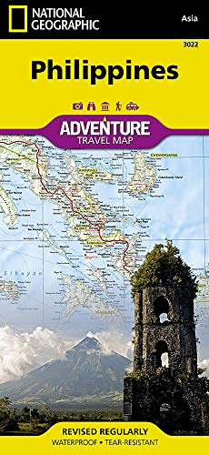
-
Oregon Trail
Francis Parkman, Anthony Brandt
Paperback (National Geographic, July 15, 2002)A classic account of the author's 1840s experiences on the American frontier with the Plains Indians describes such adventures as being lost, nearly starving, narrowly escaping Native American war parties during his journey down the Front Range and along the Santa Fe Trail. Reprint.
-
Storming A Castle: National Geographic Maze Adventures
Graham White
Paperback (National Geographic Children's Books, Oct. 1, 2002)A friends father is trapped in the dungeon of a medieval castle. To rescue him, readers must travel through secret passages, navigate a siege, scramble across a battlement, and scale the keep in a series of ever more challenging mazes that reveal fascinating details about life in the age of chivalry. Q
Q