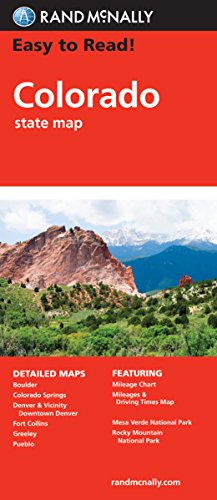
Rand McNally
Easy to Read Colorado
Map
(Rand McNally March 17, 2010)
, Fold Map edition
Rand McNally's Easy To Read State Folded Map is a must-have for anyone traveling in and around Colorado, offering unbeatable accuracy and reliability at a great price. Our trusted cartography shows all Interstate, U.S., state, and county highways, along with clearly indicated parks, points of interest, airports, county boundaries, and streets. The easy-to-use legend and detailed index make for quick and easy location of destinations. You'll see why Rand McNally folded maps have been the trusted standard for years. Regularly updated, full-color maps Larger map with a bigger type size than the Rand McNally Folded Map Clearly labeled Interstate, U.S., state, and county highways Indications of parks, points of interest, airports, county boundaries, and more Mileage and driving times map Detailed index Convenient folded sizeCoverage AreaDetailed maps of: Boulder, Colorado Springs, Denver & Vicinity, Downtown Denver, Fort Collins, Greeley, Mesa Verde National Park, Pueblo, Rocky Mountain National Park
- ISBN
- 0528881124 / 9780528881121
- Pages
- 1
- Weight
- 2.1 oz.
- Dimensions
- 9.2 x 0.2 in.
Enjoy reading Easy to Read Colorado? You may also like these books
-
R
Rand McNally
Geography & Maps Activities, Intermediate | Ages 9+
Paperback (Rand McNally May 13, 2016) -
Rand McNally
Rand McNally Historical Atlas of the World
Perfect Paperback (Rand McNally July 31, 2015) -

Rand McNally
Map It! Seek & Find Atlas of Brainy Challenges
Perfect Paperback (Rand McNally July 21, 2017) -
Rand McNally
Rand McNally Atlas of the World: A millennium edition
Hardcover (Metro Books Sept. 15, 1999) -

Rand McNally, Gavy
Mary Had a Little Lamb: A Rand Mcnally Junior Elf Book
Hardcover (Rand McNally March 15, 1955)