Rand McNally
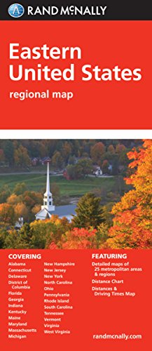
Folded Map: Eastern United States
Map
(Rand McNally Sept. 15, 2014)
, Fold Map edition
Rand McNally's folded map featuring the Eastern United States is a must-have for anyone traveling in and around this part of the country, offering unbeatable accuracy and reliability at a great price. Our trusted cartography shows all Interstate, state, and county highways, along with clearly indicated points of interest, airports, county boundaries, and more. You'll see why Rand McNally folded maps have been the trusted standard for years. Regularly updated, full-color maps Clearly labeled Interstate, U.S., state, and county highways Detail maps of major cities, a mileage chart, and a Mileages & Driving Times Map Indications of parks, points of interest, airports, county boundaries, and more Easy-to-use legend Detailed index Convenient folded sizeCoverage AreaAlabama, Connecticut, Delaware, District of Columbia, Florida, Georgia, Indiana, Kentucky, Maine, Maryland, Massachusetts, Michigan, New Hampshire, New Jersey, New York, North Carolina, Ohio, Pennsylvania, Rhode Island, South Carolina, TennesseeProduct DetailsMeasures 9.5" x 4.125" and folds out to 40" x 28".
- ISBN
- 0528881159 / 9780528881152
- Pages
- 1
- Weight
- 1.6 oz.
- Dimensions
- 3.9 x 0.5 in.
Enjoy reading Folded Map: Eastern United States? You may also like these books
-
R

Rand McNally
Geography & Maps Activities, Intermediate | Ages 9+
Paperback (Rand McNally May 13, 2016) -

Rand McNally
Rand McNally Historical Atlas of the World
Perfect Paperback (Rand McNally July 31, 2015) -

Rand McNally
Map It! Seek & Find Atlas of Brainy Challenges
Perfect Paperback (Rand McNally July 21, 2017) -
Rand McNally
Rand McNally Atlas of the World: A millennium edition
Hardcover (Metro Books Sept. 15, 1999) -

Rand McNally, Gavy
Mary Had a Little Lamb: A Rand Mcnally Junior Elf Book
Hardcover (Rand McNally March 15, 1955)